For Doug Mulholland (BMath’82), a Research and Technical Manager at the Cheriton School of Computer Science, his work flows like water.
Upon graduation, he worked for the Computer Systems Group (CSG), currently directed by Distinguished Professor Emeritus Don Cowan. Since the early 1970s, their mission has been to make technology more accessible. Initially, the team focused on making computer science technology and education more usable to first-year students. The late 1980s to early 1990s saw the emergence of networked computers and web-based technology. Many people, including researchers, government agencies and non-government organizations (NGOs) had problems that easy-to-use online mapping could greatly benefit. Yet, mapping technology was complicated, and its use was painfully labour-intensive.
"Our team’s rationale was 'We just want to tape a map on the wall, stick pins in it and show people where important sites are located'. This concept was well before Google Maps came along,” says Doug. “That kind of mapping was difficult to do and an approach we started to take was, ‘Can we make this mapping easier for others to use?’"
Doug Mulholland co-created the Flowing Waters Information System (FWIS) which monitors and helps protect Ontario’s streams
Eventually, other organizations focused on geographical informational systems (GIS): complex, computer-based tools that collect, store, and analyze spatial data, and visualize it in maps. GIS is commonly used in weather forecasting, agriculture, and navigation. CSG constructed their own simplified map viewing and editing package. They launched a suite of community information systems for communities of practice in the Waterloo Region involving heritage, arts and culture, agriculture, newcomer settlement and support, volunteer placement, First Nations stories and economic development.
One of CSG’s earliest environmental information and mapping projects was the Stewardship Tracking System, which monitors sustainability projects in Southern Ontario, such as forest restoration. Established in the early 2000s, this project was in collaboration with the Ontario Ministry of Natural Resources and Forestry (MNRF), and the Ontario Federation of Anglers and Hunters (OFAH). CSG also worked with OFAH on tracking invasive species. Furthermore, CSG partnered with the United Nations University’s Institute for Water, Environment and Health to design and maintain information and knowledge integration portals on international water practices, sustainable land management, and safe water provisioning. Over the past 30 years, CSG has used their expertise in data management to support projects in community engagement and sustainability. Notably, the CSG staff were instrumental in the City of Waterloo being named the 2007 “Intelligent Community of the Year” by The Intelligent Community Forum (ICF), a New York-based non-profit think tank.
Earth Day is a reminder that all of us are stewards of the environment. If we don't take care of these resources, then we're in grave danger of losing them.
The CSG group built these projects using their Web-based Informatics Development Environment (WIDE) toolkits: web portals that when connected to a database, can display an interactive map and disseminate information on certain points, lines and areas. With the success of each collaboration, the team explored whether external organizations could use WIDE. In late 2009, they set up a joint study with the MNRF to see if their system could complement MNRF’s database structure. In turn, CSG simplified their structure, reducing the original database from over 400 tables to about 150.
This partnership birthed the Flowing Waters Information System (FWIS), where conservation researchers can store biological and geomorphic data about flowing waters in Ontario, such as stream width and depth namely channel structure or stability, discharge, bank height, fish species including invasive or at-risk, benthic, and air and water temperatures. The team employed structured query language (SQL) relational databases, which organize information in tabular format rather than an unstructured file or document. These databases can even filter out specific information and illustrate the relationship between certain data values. FWIS also incorporates machine learning algorithms to determine a site’s habitat suitability index for various fish species. For example, how likely is it to find a certain species of fish in a stream based on their preferred temperature or stream cover quality?
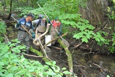
Photo of Ontarian researchers electrofishing for data analysis and collection. The FWIS works with environmental researchers to house data on water quality in a single source.
FWIS houses data on about 1,000 streams in Ontario. It contains measurements from the early 1900s, as “some were stored in printed reports or paper files in offices somewhere in the province,” explains Doug. Unfortunately, some data has been lost since the environmental sector can be very dynamic, with high staff turnover rates or people switching jobs. In essence, FWIS standardizes data so stakeholders can access it from a single source.
It also makes data collection and analysis more meaningful. Some researchers may only collect data from Northern Ontario which is known for pristine landscapes, leading to a biased assessment of Ontario’s environment. Instead, FWIS provides researchers with more descriptive metadata on why sites were chosen, such as superior water quality or certain fish species. As well, the team would examine inconsistencies within the data and verify it with the original researchers. Overall, FWIS can lead to better research protocols and decision-making for stewardship and conservation practices, which is one outcome Doug is proud of.
“We’re trying to contribute to both the science and the operations,” says Doug. “We're asking what might a future researcher need to know about our data and its suitability for their problem without having the foggiest clue what that researcher is actually trying to do or what their research objective will be.”
Surprisingly, this work intersects with various fields both in the public and private spheres. For example, FWIS can help real estate developers know if an area is suitable for housing since there’s legislation and extra costs for building in areas that have certain streams or species. It can also aid policymakers in understanding trends in climate change and sustainability. Although Doug does not conduct sustainability research like collecting or analyzing water samples, he has noticed some environmental changes while overseeing the FWIS database.
What surprised Doug the most is that there have been some significant improvements over the last couple of decades. He highlights the city’s work in naturalization, which refers to restoring an ecosystem to a more natural state, such as removing concrete linings from a stream. Doug has seen that naturalization has improved the water quality and mitigated flood risk in the Kitchener-Waterloo area. Some notable examples include Henry Sturm Creek in Kitchener, and Columbia Lake, Laurel Creek, Waterloo Park, and Silver Lake in Waterloo. Another improvement has been the reduction in the use of road salt, a major pollutant. “I have huge respect for the researchers from the Water Institute, and Dave Rudolph in particular, who managed to convince the Region of Waterloo to put up the road signs to reduce salt usage, and it has made a big difference.”
Despite these efforts though, Ontario’s environment is seriously challenged. Over the past decades, Doug has seen rising water temperatures and changes in fish species patterns around the province. “It’s not really a surprise. Everybody has said that from the day you stop doing bad things, the bad results continue for quite a while, and then there's an upswing in the change,” says Doug. “The danger is [that] there is a tipping point beyond which there may be no recovery. Then really bad things are going to happen.” Doug hopes that Canada and other countries invest more in environmental funding as studies can reveal the environment’s health and areas where improvement is needed. As well, he hopes there is more work in protecting critical environmental resources such as farmland, wetlands, headwaters, underground aquifers, streams, and lakes.
“Earth Day is a reminder that all of us are stewards of the environment. If we don't take care of these resources, then we're in grave danger of losing them.”