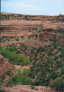
McLoyd's Canyon, site of Moon House Ruin. If you look carefully you can see water at the bottom of the canyon (April 2000).
|
McLoyd's Canyon, site of Moon House Ruin. If you look carefully you can see water at the bottom of the canyon (April 2000). |
I first heard about Moon House in May 1999 from a fellow camped next to us at Calf Creek Falls. When I described an earlier backpacking trip to Fish and Owl Creeks, he asked, "Have you ever been to Moon House in McLoyd's Canyon?" His description of the pictographs made me want to learn more, but I couldn't find any references in my personal library on Southwest archaeology. Even the name McLoyd's Canyon (which is sometimes spelled McCloyd's) rarely appears on maps. A web search only turned up some brief, tantalizing mentions, with nothing explaining where it was.
For example, an ad for the Pioneer House Inn in Bluff mentions the ruin, but doesn't give a location. Likewise, the Fall-Winter 1998 SUWA Newsletter describes how San Juan County employees "illegally drove toward the Moon House ruin within a wilderness study area located in the southeast corner of Utah", but doesn't say where the ruin is. Another mention can be found in SUWA's Summer 1999 SUWA Newsletter. Finally, Groth Expeditions September 1998 has a brief mention of Moon House.
The fight between the BLM and San Juan County over the road to Moon House was discussed in a July 10, 1999 article in the Salt Lake City Tribune. It calls Moon House a "famous cliff dwelling that, after being featured in several national magazines, drew many visitors and vandals alike." But a Lexis/Nexis search did not turn up any mentions in national magazines.
By now I was really hooked. I called BLM headquarters in Monticello, but only got the run-around. The first time, the woman I spoke to refused to tell me where Moon House was. "When you come down, I'll show you on the map," she told me. "But not over the phone."
Finally, another call to BLM produced vague directions to the site. "But we might close it off due to increased visitation," I was told. I also found a bibliography on Anasazi architecture that led me to a 1989 master's thesis of William W. Bloomer at the Department of Anthropology, Washington State University, entitled "Moon House: A Pueblo III Period Cliff Dwelling Complex in Southeastern Utah". This 213-page work tells you all you want to know (and more) about Moon House, and can be obtained by interlibrary loan from Washington State.
Despite the secrecy at the Kane Gulch Ranger Station, if you manage to get to the site, you'll find an ammo box with some plastic information sheets provided by BLM. The sheets include diagrams of the site (apparently photocopied directly from Bloomer's master's thesis, but without attribution) and a couple of pages of text.
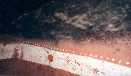
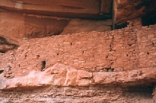 Part of site M-1, showing loopholes and snake pictograph (at top center). |
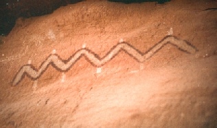 Snake pictograph (detail). |
But it's the unusual construction and pictographs that bring the visitors. M-1 has both an inner and outer section, with two walls that could well have been fortifications. Some of the peepholes in the outer wall look directly on the main path that ascends to the ruin. Room I in the middle of site M-1 is decorated in white, with a crescent moon uncolored on one wall, and a full moon uncolored on the other.
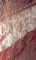 Interior of Room I, M-1. Crescent moon is visible. |
 Interior of Room I, M-1. Full moon is visible. |
Please tread lightly on the ruins. Don't walk on ruin walls. Don't touch the pictographs with your hands. Don't remove any artifacts. Leave the site as you found it, for others to enjoy.
Snow Flat is a dirt road which crosses slickrock in several places, and may require high-clearance and/or four-wheel drive. I've seen it done in passenger cars but I would not recommend it.
The USGS 7.5' topo maps Cedar Mesa North and Snow Flat Spring Cave may prove useful, although neither the trail nor the ruin are marked.
At the trailhead you'll find a parking lot on the right (south) and a BLM sign. You must pay $2 for day-hiking. Walk north along the wide trail (once a road, but BLM is doing their best to keep cars out) about 1.2 miles to the edge of the canyon. At this point look for a very steep cairned trail heading down into the canyon. After about 100 feet this trail splits. If you go to the left, you quickly reach a dramatic look-out point from where you can get a great view of the ruin. But the trail peters out here and it doesn't seem possible to continue further. If instead you go right where the trail splits, the trail traverses steep slickrock ledges down to a pour-off. You're now at the hardest part of the trail.
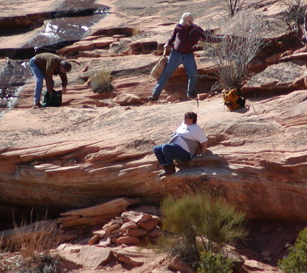 Hikers preparing to descend the pouroff. |
When you reach the M-1, the center ruin, you will see it consists of a walled area with a small entrance marked by a pile of stones. The BLM rangers I talked to all said it was OK to go in this first entrance. But they ask visitors not to enter any rooms past the first entrance. In particular, please do not enter the room with moon pictographs.
It is quite dark in some of the rooms, and a good flashlight and camera with flash are essential if you want to view or take pictures of the pictographs.
GPS:
Parking area: 37 ° 25' 06" N; 109 ° 48' 09" W.
Canyon rim: 37 ° 25' 56" N; 109 ° 47' 44" W.
M-1 ruin: 37 ° 26' 08" N; 109 ° 47' 30" W.
See Barry Meier, "U. S. Tries to Hide Indian Ruins from Intruders", New York Times, May 19 1994, p. A12, for information about how information about ruins is being excised from maps, to deter looters.
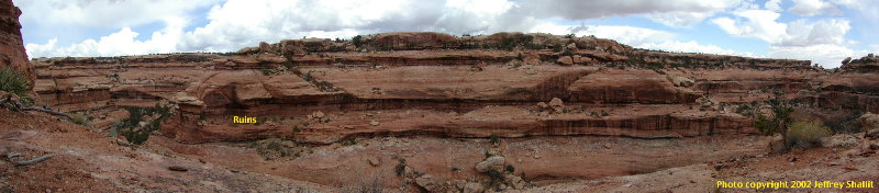 McLoyd's Canyon Panorama, March 2002 |
There's a little information about Moon House in this description of McCloyd's Canyon.
Here's my answer to critics of this page.
Interested in other sites? See this page.
Disclaimer: Hiking is an inherently dangerous activity. You could fall off the edge of a cliff, get bitten by snakes or scorpions, suffer heat stroke or freeze to death, or get sore feet. Know your limits. Carry water. Bring a map. Bring a friend. Above all, don't blame me if you get into trouble.
E-mail: