Cairn near the start of the trail in Owl Creek.
|
Cairn near the start of the trail in Owl Creek. |
Today, Cedar Mesa and its canyons are home to mule deer, bobcats, and ringtail cat.
There are a number of factors which make a trip to Fish and Owl challenging. First, the remoteness of the location: the trailhead is far from the nearest town. If you get hurt, it may be a long wait for help. Second, getting out of the canyons requires an 800-foot climb up - not so easy if you have a twisted ankle or other injury. Third, the trail requires a bit of route-finding, as cairns are widely separated (especially in Fish Creek) and easy to miss.
Don't go alone! There are several places where having a partner is useful -- the first can help boost the second up, and then the second can pull the first up. Also, lowering and raising packs by rope is pretty difficult alone.
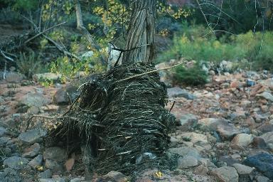 Flash flood debris surrounding tree trunk in Fish Creek. |
 (March 17, 1999)
BLM has instituted a
permit and fee system for
hiking in Fish and Owl Creeks.
(March 17, 1999)
BLM has instituted a
permit and fee system for
hiking in Fish and Owl Creeks.
On the first day we had good weather. We arrived at the trailhead at 11 AM, and set off down the trail. For the first few hundred feet, we hiked on a gentle slickrock incline. Then suddenly the trail dropped out from under us. "We're going down that?!" was my reaction.
The trail went down quite steeply, and in some places we had to sit down and gingerly inch our way forward. After about half an hour, we met a couple filtering water on their way out of Owl. They would be the last people we would meet on the trip. They warned us to be careful, as just a few days earlier someone caught their backpack on a rock, lost their balance, and was badly hurt in a fall in the canyon.
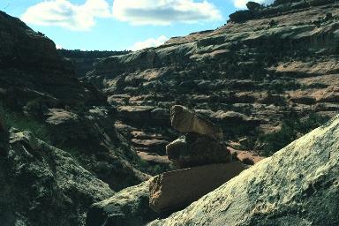
 Pour-off in Owl Creek, requiring a detour. |
We stopped for lunch next to a large pool, where we could filter water. Seventy feet above us, someone had pitched a tent on a slickrock ledge, but we didn't see anyone around.
Towards dusk we arrived at Nevill's Arch. It had taken us about six hours to go five miles.
The next morning we had breakfast, and as soon as we set off, it began to rain. It would rain continuously for the next 14 hours, with the exception of an hour for lunch.
We arrived at the confluence of Fish and Owl Creeks, which was a brushy plain occupied by cottonwoods filled with bright yellow leaves. There was a clear junction where one could turn right, to explore lower Owl Creek, or left, to ascend Fish. (The trail to the right was obvious, but had been blocked off with branches to deter you from making a wrong turn.) If it hadn't been raining, we might have been tempted to detour, but the continuous rain dimmed our spirits.
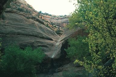
 Nevill's Arch, Owl Creek. |
As we ascended Fish Creek, we stopped twice to watch Mule Deer. The day was very grey and chilly, and the cotton clothes we wore were getting soaked. We changed into polypropylene, Gore-Tex, and wool, and had lunch during a brief respite from the rain.
The hiking here was quite easy, over a series of slickrock ledges. After a few miles, Fish Creek began to get narrower, and the constant rain made us think seriously about the possibility of a flash flood. We tried to keep possible routes of egress in mind, were we to hear the "freight train" sound that would signal a flash flood.
At about 5 PM, we began to search for a campsite. Our first choice was abandoned when we realized that five feet above us was some flash flood debris. We had to backtrack half a mile to find an accessible bench fifty feet above the canyon floor, where we would be safe from any flash flood. The ground was muddy, and we were cold and wet. We set up the tent and crawled into our sleeping bags. It continued to rain until midnight.
At midnight I awoke and heard the water rushing in the creek below. It sounded like a torrent. Would we really be able to make the exit tomorrow? It didn't sound promising.
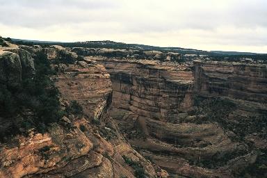 View of Fish Creek Canyon from the rim of Cedar Mesa. |
Finally we reached the place where the trail starts sharply up to exit Fish Creek. We climbed up, resting frequently. Although there were no really dangerous exposures, the uphill grade was significant. Finally, we reached the last 20 feet of the climb, where there was a crack too difficult to ascend with packs. We got out our rope, and I climbed the crack. My hiking partner attached the rope to the packs, and we lifted them up. Finally, he ascended the crack.
The view from the top of Cedar Mesa was remarkable. We rested, and celebrated our exit from the canyon. It remained to traverse two miles of a winding path on Cedar Mesa back to the Owl trailhead.
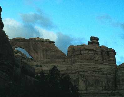
 Trail along Cedar Mesa from Fish to Owl Creek. |
Maps can be purchased, for example, at the San Juan Resource Area BLM headquarters in Monticello.
The map in Michael Kelsey's book, listed below, may help identify the locations of ruins and arches.
Trails Illustrated also sells the waterproof Map 706 (Grand Gulch Plateau), which has the advantage that you can read it in the rain, but the detail in this 1:62,500 map isn't anywhere near as good as the USGS 7.5".
While you're at it, send a big donation to SUWA, the Southern Utah Wilderness Alliance. These fine folks are trying to save wild Utah.